Linking air quality with traffic and population to support healthier urban decisions
Air pollution is not only about where pollutants are present, but also about who is exposed to them. Especially in cities, people are living and working close to elevated levels of air pollution. However, air quality can differ significantly from street to street and from hour to hour.
RETINA helps to understand spatial and temporal exposure patterns by combining air quality measurements with atmospheric modelling. Within GreenEO, it supports more targeted and health-relevant urban air-quality analysis.
From pollution levels to human exposure
Due to the high cost of air-quality monitoring, measurement networks in cities are often sparse, if available at all. Air-quality models can provide complete maps of pollution levels, but may not always accurately reflect true surface concentrations.
RETINA bridges this gap and translates environmental data into exposure information, providing user-friendly tools to identify where air pollution is most likely to have the greatest impact on human health.
What is RETINA?
RETINA combines measurements with air-quality modelling to provide a detailed, observation-based picture of urban pollution. In cities where ground-based measurements are limited, satellite observations are incorporated to strengthen the monitoring.
RETINA provides hourly air-quality information at street level, accessible through interactive maps and user-friendly tools. In addition to near-real-time monitoring, RETINA delivers a 48-hour air-quality forecast, helping decision-makers anticipate upcoming pollution events and take timely action to reduce exposure.
Estimating exposure in cities with RETINA
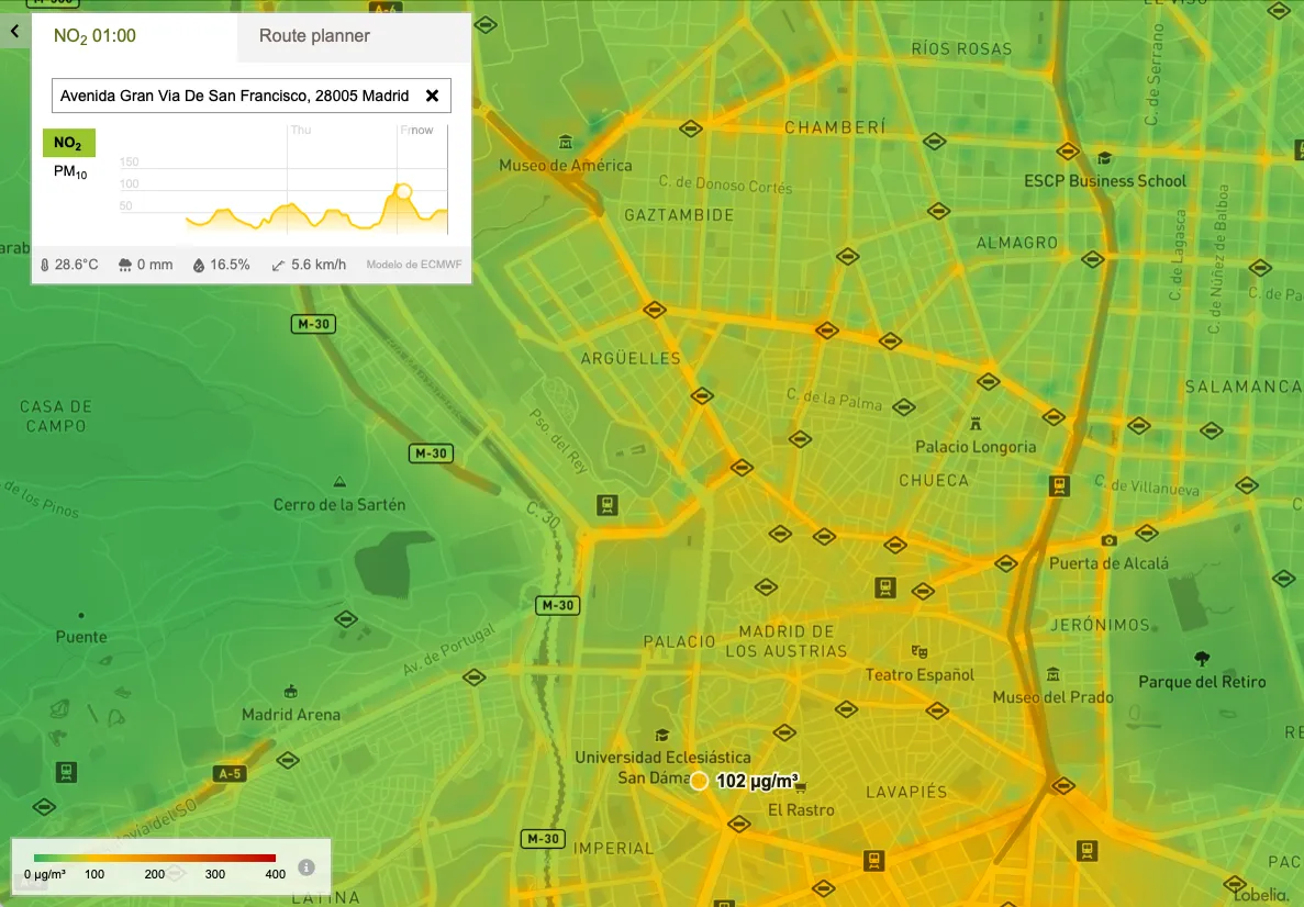
Figure: Map and time series of street-level NO₂ concentrations in Madrid, provided by RETINA and Lobelia Air.
RETINA combines air-quality measurements, satellite observations, and atmospheric modelling to create a detailed, observation-based picture of urban pollution. At its core, RETINA uses a physics-based dispersion model to simulate how pollutants are emitted and transported through a city. These modelled concentrations are compared with available ground-based observations, and satellite observations.
Using data assimilation, RETINA continuously adjusts the underlying emission estimates to reduce the differences between modelled and observed pollution levels. This allows the system to identify where emissions are likely to be higher or lower than expected, while maintaining the physical relationships between emissions, meteorology, and air pollution.
The optimised emissions are then used to produce high-resolution, hourly maps of air quality at street level. By combining observations with the strengths of atmospheric modelling, RETINA can provide reliable pollution information even in cities where measurement networks are limited. The resulting information can be used for near-real-time monitoring, exposure assessment, and short-term air-quality forecasting.
A focus on exposure
RETINA is valuable because it provides an observation-based picture of urban air pollution by combining measurements with physical air-quality modelling. Its portable design allows it to be adapted to different cities, while its relatively low computational requirements support near-real-time applications. Interactive, user-friendly tools make the resulting data accessible for exploring pollution patterns, identifying hotspots, and assessing potential exposure.
This makes air-quality information more directly relevant for public health and urban planning. It helps cities prioritise actions where they can have the greatest impact on reducing exposure.
Retina within GreenEO: supporting health-relevant air-quality insights
Within GreenEO, RETINA is being demonstrated in four cities: Amsterdam, Rotterdam, Zaragoza, and Tirana. These trials explore the added value of new satellite instruments, including Sentinel-4 and Sentinel-5, for urban air-quality monitoring, and the lessons learned will feed directly into RETINA's further development. Once validated, the approach can be extended to other cities, both within and beyond Europe.
By translating pollution data into exposure insights, RETINA supports more informed decisions across urban planning, transport policy, and environmental health strategies. For example, by mapping where pollution levels are highest relative to population density, a city could identify neighbourhoods where residents face the greatest exposure. Thus, informing decisions such as rerouting traffic away from schools, prioritising low-emission zones, or targeting green infrastructure where it would have the most benefit.
Curious about what is next?
Stay up-to-date on GreenEO’s research and results, by following us on LinkedIn